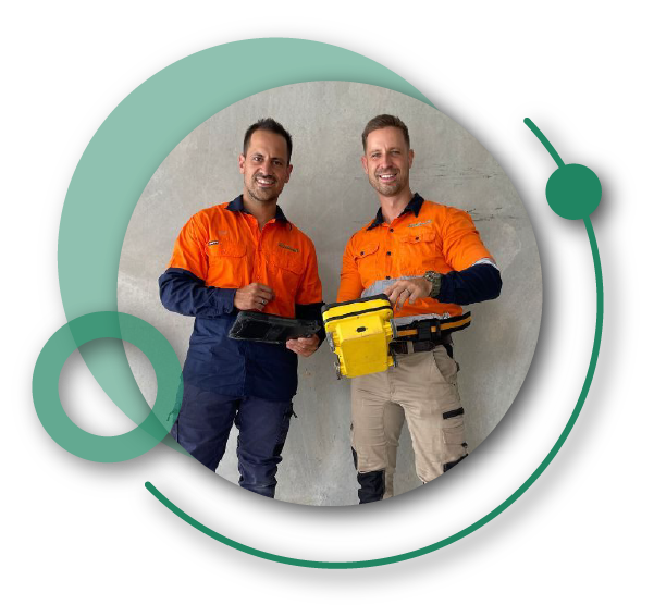
Welcome To

South East Scanning

Concrete Scanning Services

Dial-Before-You-Dig Utility Location

Non-Destructive Testing

CONCRETE X-RAY

1CONCRETE CUTTING-80

Concrete Cutting

Concrete Radar

Concrete Slab Inspection

subsurface-imaging-image1

Advanced GPR Data Processing

advanced-gpr-data-processing-image2

Subsurface Imaging

Structural Investigation And Analysis

Slab Scanning

Drone Surveying

Geotechnical Surveying

Consulting Services

Ultrasonic Pulse Velocity (UPV) Testing

Download PDF GPR Report

GPR Scanning Reports
for Project Managers & Engineers

MEET AIDAN AND DION

The Founders Of South East Scanning

South-East Scanning was founded by Aidan and Dion, two brothers from Melbourne, who brought together their extensive experience in the built environment and professional services sectors.

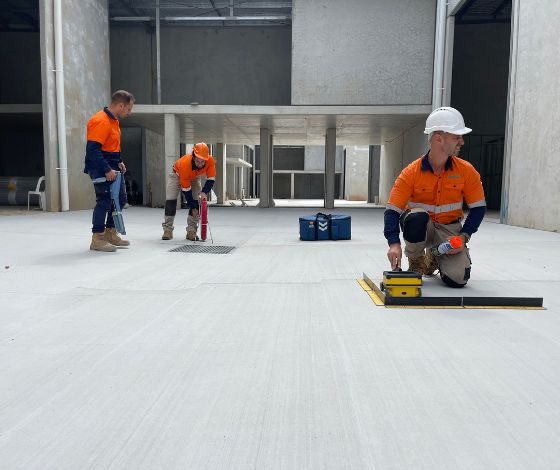
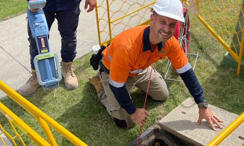
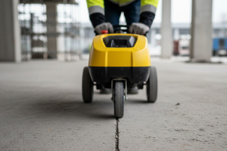
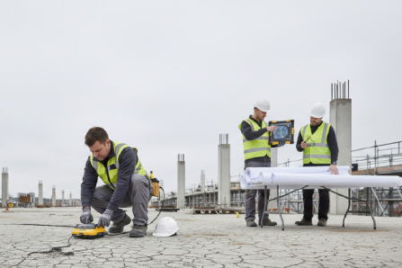
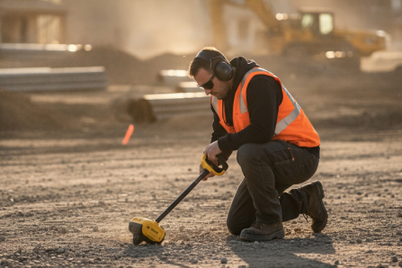
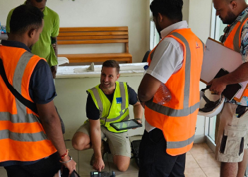
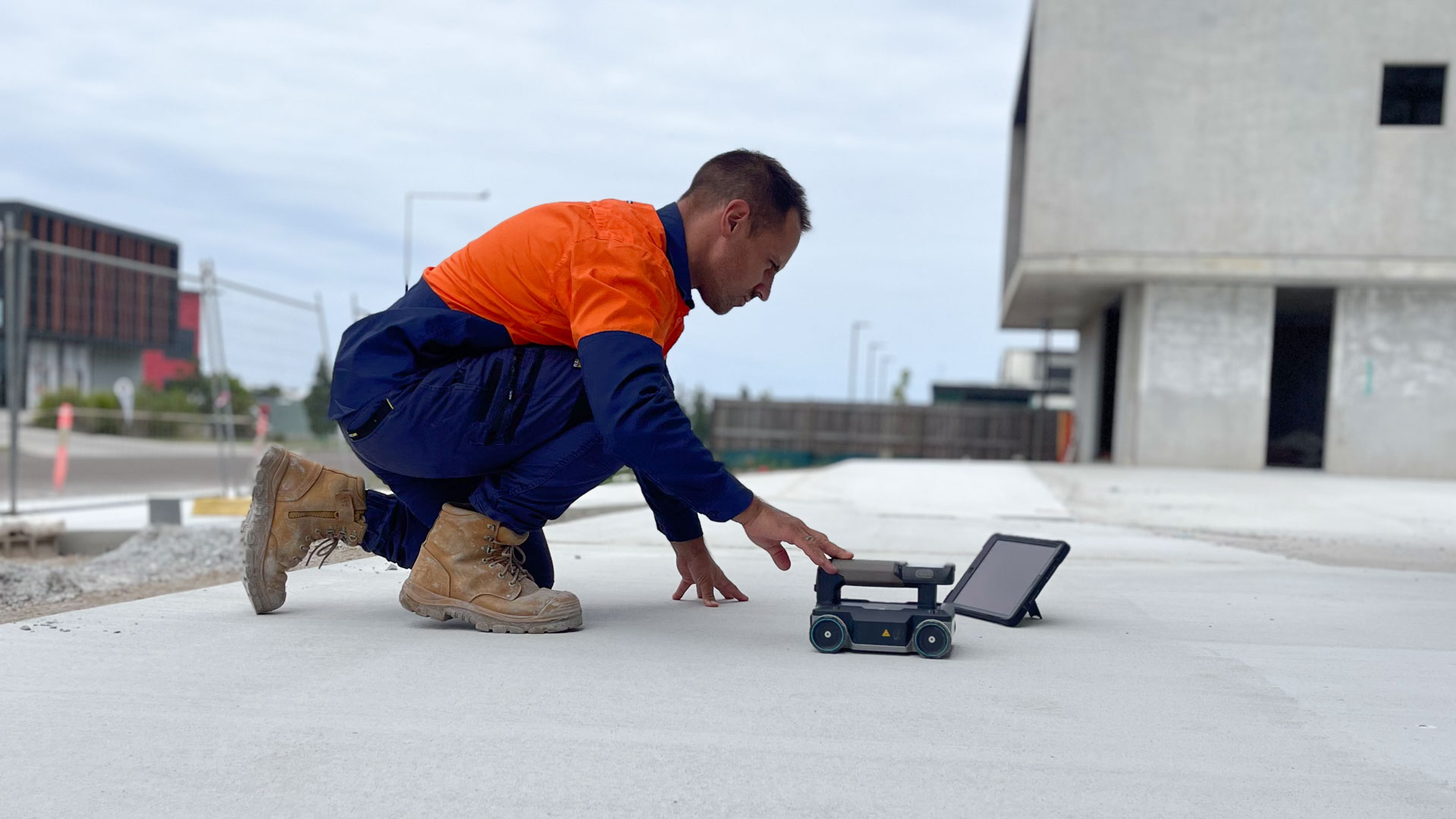
After relocating to South-East Queensland, they established South-East Scanning to fill a niche in the building and construction industry, specialising in ground-penetrating radar, concrete scanning, non-destructive testing, and utility locating services. Their background provided a strong foundation for the business, allowing them to offer expert insights and innovative solutions to meet the complex needs of their clients in the region.

We look forward to assisting you. Please call 1300 175 543 or use the form below for a fast response.

meet-the-owners-graphic-png
south-east-scanning-logo-final-outlines copy

Is In Partnership With

Our Mission

At South-East Scanning, our mission is to help our clients understand sub-surface structures and mitigate their risk with our expertise in ground penetrating radar and utility detection. We are a family business with unique insights and a commitment to our clients’ success.

Company

profile

South East Scanning was established to meet the needs of a variety of industries on the Gold Coast that required concrete scanning services at a highly professional level.

We perform our scanning work with the utmost care and attention to detail, combined with quick reporting and reliable service.

Our service was created to assist a variety of industries including Builders, Plumbers, Concreters, Carpenters, and Structural Engineers.

Why South East Scanning is Brisbane's preferred concrete scanning company

Queensland’s Most Trusted Subsurface Imaging Experts

Trusted by Queensland’s top builders and engineers, we safeguard your projects with advanced subsurface imaging and reporting solutions, keeping you on track and worry-free. Connect with us to strengthen your risk management strategy and deliver with certainty.

Our Simple and Easy 6 Step Process!

1. Online Quote

Complete our online quote form and one of our team members will be in contact shortly.

2. Site Visit

We come on-site and view the job, providing you with an accurate quote.

3. GPR Scan

We complete our GPR Scan of the job, covering all areas required.

4. Instant Engineer's Report

We provide a site summary report, detailing our findings.

5. Option To Cut Or Core

We provide the option to cut or core the area, which is the process of cutting or drilling.

6. Follow Up Advice

We provide follow up advice on what the best course of action is, prevention and potential problems in the future.

SAFETY IS OUR PRIORITY

Work With A Trusted Trader

Explore our certifications and feel confident that your South East Scanning project is certified to be executed correctly and to the highest industry safety standards. 

Qualified Concrete Scanning

Accredited Statement of Attainment, by Nationally Recognised Training, For conducting concrete scanning using ground penetrating radar (GPR)

Dial Before You Dig Certified Locator

For being qualified in risk assessment, utility locating methods, and accurate identification of underground assets following industry safety standards.

Certified Locating Organisation

For complying with CLO standards to gain access to Telstra pits and manholes for cable and plant location and other utility assets.

Qualified Local Buy Supplier

Statement of Verification, for successfully being verified as a local buy Pre-qualified Supplier.

LICENSED BY:

Download PDF GPR Report

How Reliable Is Your Subsurface Utility Data?

GEOTECHNICAL SURVEYING

Geotechnical surveying is the process of studying the physical properties of soil and rock formations to determine their suitability for construction projects. This involves collecting and analysing soil and rock samples, conducting field tests, and assessing geological and environmental conditions.

South East Scanning is the best choice for geotechnical surveying due to our experienced team of professionals and state-of-the-art equipment. We use non-invasive methods such as ground-penetrating radar and electromagnetic induction to provide accurate and reliable data. With a focus on safety, efficiency, and customer satisfaction, South East Scanning is the top choice for geotechnical surveying services.

Our Values

South East Scanning aims to build trusting, long term business relationships with our clientele. We identify the following values as core to our business operations:

TRUST

We aim to be honest and open with our clients at all times.

INNOVATION

New technology has changed the way we operate. We embrace new innovations in work practices and equipment.

EMBRACE FEEDBACK

We take on any negative or positive feedback with an open mind to allow us to become better as an organisation.

CUSTOMER SERVICE

Our team will go above and beyond to ensure our clients expectations are either met or exceeded.

Speak With a Scanning Specialist

Project-Critical Certainty Starts Here

Whether supporting design validation, structural assessment, or infrastructure investigation, our team provides precise subsurface intelligence when accuracy matters most.

Our Service Area

  • Brisbane

  • Gold Coast

  • Booral
  • Bundaberg
  • Dundowran
  • Dundowran Beach
  • Eli Waters
  • Fraser Coast Region
  • Kawungan
  • Nikenbah
  • Pialba
  • Point Vernon
  • River Heads
  • Scarness
  • Torquay
  • Urangan
  • Urraween
  • Wondunna
  • Gympie
  • Gladstone
  • Rockhampton
  • Cairns
  • Townsville
  • Mount Isa

Got Questions?

Frequently Asked Questions

Everything you need to know about our scanning, locating, and concrete services — straight from our team.

We are specialists in structural diagnostics, NDT, and risk mitigation. South East Scanning provides three main services:

  • Subsurface diagnostics — slab settlement investigations, void detection, moisture intrusion analysis and infrastructure assessment.
  • Construction risk mitigation — dial-before-you-dig, service and utility location, ground penetrating radar, concrete slab scanning for reinforcement, post-tension cables and embedded services.
  • Infrastructure condition assessments — bridge deck investigations, concrete deterioration mapping, reinforcement surveys.

Yes. We are a CERTLOC Certified Locating Organisation, and are proud to be. Our technicians are also Certified Locators, having met the stringent requirements of the CERTLOC Certified Locator Practical Assessment, demonstrating their high level of field capability.

CERTLOC Certified Organisation

The duration depends on the size and complexity of the area being scanned, as well as the stated outcome. Small residential jobs may take an hour, while large infrastructure investigations may require several hours or multiple days.

It also depends on scope — are you scanning for core hole penetrations? How congested is the slab? Do you need to identify structural beams and footings? All of these variables will affect the time our technicians spend on site.

We have a two-hour minimum call-out, which allows our technicians time to attend the site, scope the work area, conduct a GPR scan and take site notes for the preparation of a formal report.

The idea that our service is free is a common misconception. You can order plans from BYDA free of charge; however, the service of having a certified locator attend the site, open pits, mark up the ground with paint, inspect the site using ground-penetrating radar, and provide a comprehensive site report is not free.

No. We cannot eliminate risk. Utility locating is a risk-mitigation measure, not a risk-elimination measure. However, the more information that we have available — private site plans, civil construction plans, and complete site access — the greater the likelihood of success.

That depends. Conductive utilities, such as electrical and copper telecommunications services, are relatively easy to trace. For polyethylene water or gas lines, we rely on ground-penetrating radar, which does not guarantee successful location every time and is highly dependent on the work area, surface, and soil type. Sometimes these utilities are laid with tracer wires, which make them easy to locate. For sewer and stormwater lines, we generally need access to a manhole or inspection opening to insert a trace rod.

We locate fibre-optic cables using a trace rod inserted into the cable duct, as fibre-optic lines are non-conductive.

That depends on the quality of the signal our transmitter generates. If we have a strong, consistent, round signal, we are confident of the utility's position. If the area is heavily congested with utilities, overhead power lines, temporary fencing, or other signal impediments, our accuracy can be affected.

AS5488, the Australian Standard that governs subsurface utilities information, provides a 300mm width tolerance and a 500mm depth tolerance on site markings. We can generally locate utilities to within a far more accurate degree; however, it is worth noting these tolerances before excavating.

Quality levels (QL) range from A (most accurate) to D (least accurate). Think of them as degrees of confidence rather than accuracy.

  • QL-A — the utility has been potholed and physically verified.
  • QL-B — a strong, consistent EMF reading with a verified depth.
  • QL-C — visual surface features confirming a utility's location, but no EMF or GPR readings.
  • QL-D — no information beyond the site or BYDA plans.

We receive this question quite a lot. Dial-before-you-dig is now BYDA (Before You Dig Australia). BYDA provides free utility plans to the public; however, these are QL-D and require a skilled locator to inspect the site and physically locate the utilities.

It depends on the site context. We generally rely on ground-penetrating radar to find water pipes; however, site context and depth matter. If we are looking for a 20mm polyethylene line in a front garden, we can likely find it. Under reinforced concrete, the likelihood drops significantly.

We often recommend potholing water utilities when an accurate location is required and conventional methods such as EMF and GPR have been unsuccessful.

Generally, yes. If you are building near public infrastructure that traverses your property, you need a utility location report from a certified locating organisation to the QL-B standard, confirming depth, orientation, and distance from the property boundary. You will need this to submit a build-over application (BOA).

We need to confirm access to a manhole before attempting to trace the utility. If you have a sewer manhole on your property, great — if not, you may need to arrange access through your neighbours.

Our handheld GPR systems can scan most concrete slabs and provide information on reinforcement bar configuration, slab depth, concrete cover, and the presence of post-tensioned cables, embedded conduits, and anomalies such as voids or honeycombing.

As a rule, we can achieve a depth of around 500mm; however, the GPR signal attenuates the deeper it scans and the more heavily congested the slab. For heavily reinforced podium slabs, we rely on alternative testing methods such as UPE.

Max depth approx. 500mm

UPE stands for Ultrasonic Pulse Echo testing. It is a non-destructive testing (NDT) method that uses high-frequency sound waves to inspect the internal structure of concrete by emitting pulses and analysing echoes from defects or boundaries. It enables scanning from one side to identify subsurface voids, cracks, and thickness — very useful for detecting anomalies at depths beyond the reach of GPR.

Unfortunately, there is no defensible way to determine reinforcement bar diameter using NDT alone. We use a Proceq PM8000 Profometer (cover meter reader) to obtain bar diameter estimates; however, these are subject to several limitations, including a maximum concrete cover depth of 63mm. If you require a specific diameter, you must take a core sample or break out a section of concrete.

Yes. Using a combination of GPR and UPE, we can easily identify voids. A common request is to check Besser-block walls for voids due to insufficient concrete vibration, or to check slabs for voids or cold joints where the concrete pour was staged.

Yes, absolutely. Our investigations can provide engineers with critical information about reinforcement layout, internal defects, and anomalies such as voids and delamination. Our detailed reports assist with structural assessments, remediation planning, and asset management strategies.

Yes. We have conducted many asphalt thickness assessments for major clients and are well-versed in the methodology. We use high-frequency radar and specialised data analysis to determine accurate asphalt thicknesses as part of road or deck-wearing-surface assessments.

We have two methodologies. We use a Proceq Silver Schmidt Rebound Hammer to test surface hardness — a spring-loaded tool that analyses rebound responses. Where a definitive MPa value is required for an engineering assessment, we scan the slab, identify suitable coring locations, remove 3–4 core holes and send them to a laboratory for testing. This destructive method is the most accurate way to measure concrete's MPa.

There are multiple reasons why concrete might crack. The size and path of cracks often indicate whether the cracking is geotechnical (soil-related), curing- or expansion-related, or related to reinforcement bar placement. Our scanning assessments can help narrow down the cause by providing key insights including concrete cover depth, whether mesh was correctly placed, or whether there is a moisture or groundwater issue.

There are many reasons why moisture may leak through a slab. Water intrusion through concrete floors may result from hydrostatic pressure, slab cracks, rising damp, poor waterproofing, or leaking services beneath the structure. Subsurface investigations can help determine whether moisture is coming from beneath the slab or from within the concrete structure itself.

A sagging slab typically results from a loss of support. Possible causes include soil erosion, leaking pipes (commonly stormwater), poor soil compaction, and voids beneath the slab caused by soil washout or an incorrect concrete mixture. Our subsurface diagnostic strategies can help identify the exact cause of the sag.

Still have questions? Our team is ready to help — get in touch today.
Contact Us

Keep Up To Date

With Us On Socials

Let's Get Your Project Started!

Please complete the quote request form below and we will respond to you promptly.

If you are using a VPN please contact our team directly via our phone number or disable your VPN, our phone number is: 1300 175 543

This field is for validation purposes and should be left unchanged.